|
File Management |
This is a general discussion topic designed to explain how and where Think GIS stores its data.
Map File (.TGM or .TMA)
The Map file, or project file, is a collection of layers. All of the lines and data within Think GIS are stored in their individual layer files (see below). The map file simply stores a list of layers commonly used together for a specific purpose or application. Layer Settings are also stored in the map file. These parameters control the visibility, color, symbol, color coding rules, and other display attributes for each layer.
It is common to have multiple map files that all utilize a common set of layer files. This way a layer can be included in one map but not another. Or a layer can be green in one map but gray in another. And since the contents of each layer are stored in only one place, any changes made to a layer in one map will automatically show up on any other map using that same layer.
Typically all the layer files (*.tml) and one map file (*.tgm or *.tma) are stored together in the same folder named according to the city, county, or region that they cover.
See also TGM vs TMA.
Layer Files ( .TML )
Each layer stores its contents in a file named with the TML extension. This file stores both the geometry and database information for a layer. The contents of a layer are organized as follows:
•The primary content of a layer can be thought of as a database table where each row is a feature and each column is a field. Each layer can be configured with its own set of fields and its own form layout used to view individual feature records one at a time. This organization is best demonstrated in the map Index.
•Each feature record can be represented on the map with one or more entities. An entity is a polyline, symbol, area, label, or raster image drawn on the map. The relationship between features and entities is a parent/child relationship where the feature is the parent and the entities are the children. Each parent can have several children and each child has only one parent.
•Example: A layer called "Roads" contains a feature called "River Rd". River Rd is represented on the map with 7 polyline entities each tracing a section of the road's centerline and 2 label entities marking where the feature is labeled.
•The layer file also stores Advanced Layer Settings, Layer Format, Form Layout, Layer Password, Feature Links to other data, Map Projection, and other settings.
To allow access to data outside of Think GIS, any layer that has a field type that is not natively saved in the .tml will now have a corresponding .xml written to the same file location as the .tml when either unlocking the layer or exiting the map if changes are saved. The XML file name will be the same as the TML file name. The critical fields which will affect this are:
•Calculated Length
•Calculated Area
•Area Search Results
•Linked Database Field
•Calculated Coordinates
•Calculated Expression
•Nearest Feature
•Concatenate
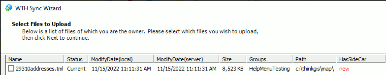
A TMGUID field must be added for these values to be available on ThinkGIS.com maps. These XML files will be automatically uploaded with the parent TML file. Sync will note this as, "HasSideCar," which will populate this column with the file status.
Think GIS has the ability to use OGC Web Map Services (WMS) using version 1.1.1 that support JPG and PNG image types. The source must provide an option in the same state plane coordinate system as the customer map to be utilized. This is most often used for aerial photography layers. These are some examples that are in use:
Please contact WTH customer support for consultation on whether a specific WMS source is compatible or for help setting up a WMS layer.
OGC Notes:
•Think GIS does not support WGS 84 coordinate system at this time.
•Learn more about OGC WMS standards here, OGC Standards.
•If the WMS source is unavailable for any reason Think GIS will log an error message.
Workstation Settings file ( tm4.ini )
Settings specific to each computer are stored in the tm4.ini file. Many of these parameters are accessible to the user through the Workstation Settings window. These settings apply to Think GIS regardless of which map is open.
Program Files
TM4.exe or TM4Viewer.exe, and supporting program files must be installed on each workstation or stand-alone computer where Think GIS is used. Typically this is the c:\thinkgis directory.
Aerial Photography files
Aerial photography files are typically very large files totaling several gigabytes in size. These files are typically stored in their own folder. Each image file is referenced on the map by a feature containing the file name and an entity marking the location of the image on the map. See Import Images for more details.
Symbol Library
A symbol pick list is stored in the file symbols.tmd. Any additional symbol libraries will have the .tsl extension. To select a symbol or manage symbol libraries see the Symbol column in Layer Settings.
Map Projection Library
The projections.tmd file is a user definable projections pick list. Any time a new map is created or a task requiring a re-projection is executed, a new projection must be selected from this list. Think GIS supports three general types of projections:
•Latitude/Longitude (unprojected)
•Transmercator (including UTM)
•Lamberts Conical
Line Style Library
The LineStyles.tll file is a custom line type pick list. To select a line type or manage custom line types see the Line column in Layer Settings.
Linked Files
Certain layers of the map may be set up to refer to external files such as pictures and databases. Some topics that can help users better manage these files are Global Links, Feature Links, Path Variables, and Data Directory.
|
Copyright © 2026 WTH Technology |