|
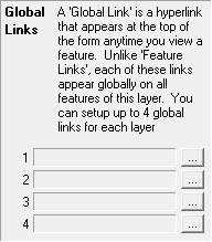
Global Links |
This column of the Layer Settings window can be used to setup or edit Global Links. A Global Link is a link stored in the map file that appears on the pop-up feature information window for all features of this layer. Global links often contain field names in their commands that act as variables so that the same link executes differently for each Feature. When clicked, a link typically runs a third party program, displays a picture, or executes any Think GIS command. Starting in Think GIS version 4.22, users can configure up to 4 global links for each layer.
To setup or edit a Global Link
1)Open the Layer Settings window
2)Click in the "Glob Link" column for the desired layer
3)Click the ![]() button next to one of the 4 link slots
button next to one of the 4 link slots
4)Fill in the Global Link dialog box
5)Click OK
Notes:
•The Link Examples page provides samples of link paths.
•The use of path variables within a layer is important to assure that the information will be usable by other users. For more information read about Data Directory and Path Variables.
•Using Variables: Field values can be inserted as variables into file names or commands by typing the field name in <> brackets. This makes it possible to setup a single link that works differently for each feature. Ex., <BridgeNum>.jpg
•If the field is not populated the link will be grayed out.
•The Data Directory is configured in Layer Settings.
•Using Data Directory: For best results, never refer to a file using an absolute path such as "F:\2008Pics\123.jpg" because other users of the layer may not use this same drive letter or folder name. In this example it would be better to set this layer's 'Data Directory' to "F:\2008Pics" and then refer to the file simply as "123.jpg" in the link. Each user can then modify the Data Directory setting if necessary for their map.
See also Feature Links
|
Copyright © 2026 WTH Technology |