|
Symbol Type |
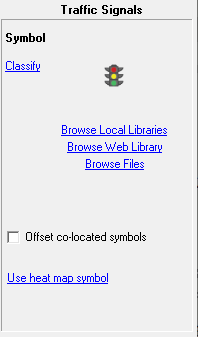
Click on the interactive image below for more information.
Classify Click here to set up rules for assigning different symbols to different features on this layer. Click Here for more info.
Browse Local Libraries Click here to change the symbol for this layer by selecting from one the symbol library files located on the computer. See Symbol Library for more information
Browse Web Library Click here to change the symbol for this layer by selecting from one of the symbols in WTH's web based library. The web library may have more up-to-date symbols than those installed on the computer. And the web library contains larger and more color rich symbols than the local symbol libraries are capable of holding.
Browse Files Click here to import an image file from the computer to use as the symbol for this layer. Think GIS supports bmp, png, or jpg file formats for symbols.
Offset Co-located Symbols When this box is checked, any symbols placed at the same location get spread out slightly when displayed so it is obvious that there is more than one symbol at the same location. This is especially usefully when geocoding a set of data such as crime stats.
Show legend on screen This checkbox is only displayed when the symbols are classified. Checking this box displays a legend on the map showing the symbol classifications.
Use Heat Map Symbol Click here to display the heat map setup screen. heat maps are designed to point out areas of high concentration of points. The result is similar to using a spray can to put one shot of spray at each location such that the more congested areas receive the most color.
Show heat colors in legend This checkbox is only displayed when using the heat map style symbol. Checking this box displays the heat color ramp in a legend on the map.
To change the symbol for a layer
1) Open the layer settings window
2) Click in the symbol column for that row
3) Click "Change Symbol" in the symbol properties window.
4) Select a symbol from the symbol library window and click OK.
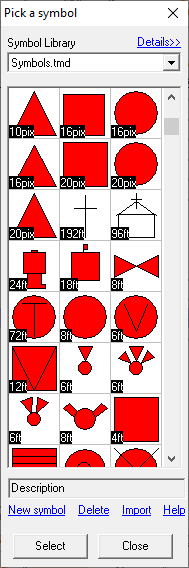
Symbol Library File Management:
•The pull down list at the top of the Symbol Library window allows users to select which symbol library to be browsed. Each symbol library is its own file located in the Think GIS directory. These files are named with the .tsl extension or the original symbol library file was named symbols.tmd.
•The symbol library file is only used during the selection process. After a symbol is selected it is copied into the map file. So, for example, to distribute a map to others containing a new symbol, it is not necessary to distribute the symbols library file.
•Symbol libraries can be merged by using the Import Symbols button shown above.
Notes:
•All vector based symbols are drawn using the line color defined in Line Properties and are filled using the fill color defined in Fill Properties.
•Like most other layer settings, symbol types are stored in the map file (.tgm or .tma).
•The practice of assigning symbols to individual features in now obsolete. Read more.
|
Copyright © 2026 WTH Technology |