|
Using GPS with Think GIS |
Track my location on the map as I drive down the road
Connect the GPS to the COM port on the laptop (or USB port for some models) and watch a little white dot on the map move down the road along with the unit. Think GIS will even automatically pan the map to keep up with as it is driven off the screen. Going somewhere? Lookup an address on Think GIS and the map will automatically zoom to a view showing both the unit and the destination. As the unit gets closer to the destination, Think GIS zooms in closer. Think GIS can permanently record the route by automatically drawing lines on a layer marking everywhere the unit has been. See GPS Setup for more information.
Collect data with GPS and upload it to the map (Garmin GPS receiver only)
Take the GPS out in the field and record points using the Mark Waypoint functionality available in most GPS units. It may also be used to record the path of travel for the entire trip as a "track log" on most GPS units. Once all points are collected, connect the GPS to the PC to upload waypoints and track log to a layer on the map. See Importing from GPS Device for more information.
Collect data with GPS and upload it to the map (Other receivers)
If the GPS receiver stores its waypoints in a GPX file then Think GIS can import those into the map. See Importing from GPX file for more information.
Download data from the map to the GPS (Garmin GPS receiver only)
Using the maps aerial photography, place symbols on several points to be inspected in the field. To do this, download this data to the GPS as waypoints and track log, then take the GPS out in the field and easily navigate to those points. See Exporting to GPS Device for more information.
Manually lookup GPS locations on the map
Using the GPS unit stand over a point in the field and write down the Longitude/Latitude coordinates on the GPS display (see note on Interpreting Coordinates below). Once back at the computer, type in these coordinates using Locate Point for Coordinates You Enter and Think GIS will locate that point on the map.
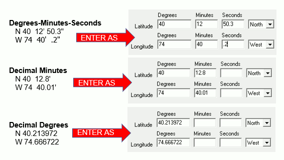
Interpreting Coordinates:
When reading a coordinate from the GPS display or other source, it is very important to know which format the GPS is displaying so that the numbers can be entered correctly into Think GIS.
Automatic Vehicle Locating (AVL)
Using additional radio or cellular technology, users can track an entire fleet of vehicles from the Think GIS display in the office. See AVL, or contact WTH Technology for more information.
|
Copyright © 2026 WTH Technology |