|
Address Finding |
It is important to understand how Think GIS looks up addresses so that users can configure the data to offer the greatest flexibility to the end users. Think GIS recognizes a layer in the map as being an address layer if it is formatted with a set of pre-defined field names. The Geocoding column in Layer Settings shows which layers Think GIS has recognized as properly formatted address layers. Address layers can be formatted for either address points or address ranges.
Multiple Address Layers:
If Think GIS recognizes multiple address layers on the map then it will search all of these layers (up to 100 layers) with each address lookup request. There is a checkbox option in Layer Settings which can be used to exclude certain address layers from the lookup process. Each format is described in the sections below. There are some reasons to organize the addresses into multiple layers. Here are some examples:
•By putting city addresses on a separate layer from the county addresses, different offices can maintain their own addresses.
•If using both address points and address ranges on the same map, they need to be separated into different layers.
•Special addresses such as cell towers (used to locate wireless 911 calls ) typically generate a lot of overlapping screen clutter with their coverage areas drawn. The solution to this is to put them on their own layer so that it can be turned off or set up with different display attributes independent of the other addresses.
An address points layer is typically organized such that each Feature represents an individual address. Each Feature is represented on the map with a single symbol Entity placed over the center of a building (or door of a building in the case of individually addressed units). Users can include any number of fields in the address point layer as long as the first four fields are as follows:
•"street"
•"dir"
•"zip" or "community" (If both fields included then uses which ever is listed first)
•"house"
The number of sort fields for the layer must be set to 4 or greater. Think GIS will also make use of any field named "suffix", "apt", or "lot" but it is not required. Users can confirm or edit the field layout of any layer by accessing its Layer Format from the Layer Settings window. Once most of the address points are completed, a user can successfully lookup just about any address even when the requested address is not included in the address point layer. Think GIS does this by approximating the location of an address based on surrounding address points on the same street. So if a new house was recently built that is not yet included on the address point layer, Think GIS will usually be able to find it anyway.
Address Ranges Layer:
An address ranges layer is typically organized such that each Feature represents a city block or any length of road from one intersection to the next. Each Feature is represented on the map with a single polyline drawn along the centerline of the road in the correct direction. Users can include any number of fields in the address range layer as long as the first eight fields are as follows:
•"street"
•"dir"
•"left zip" or "left community"
•"right zip" or "right community"
•"left from"
•"left to"
•"right from"
•"right to"
The number of sort fields for the layer must be set to 8 or greater. The from fields can be higher or lower than the to fields, however, it is important that the polyline draw on the map be drawn in the correct direction. To determine polyline direction use the Layer Settings window to assign the arrow line style to this layer.
Odd and Even sides of road are determined by the parity of the from and to fields. For example, if the left from and left to fields are both odd then the left side of the road will be assumed to have odd numbers.
Address Ranges Layer (Format 2):
One slight variation to the standard address range format above is one in which a common zip or community is used as follows:
•"street"
•"dir"
•"zip" or "community"
•"left from"
•"left to"
•"right from"
•"right to"
Address Ranges Layer (Format 3):
Think GIS will also recognize range layers formatted like this:
•"street"
•"dir"
•"zip" or "community"
•"from"
•"to"
Search Results:
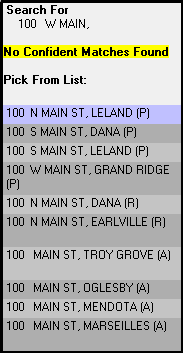
If searching for an address and not selecting a search suggestion result, all possible results will be displayed in the Info Window.
After each entry in the list, there will be a letter A, P, or R in parenthesis. Their meaning is as follows:
•(P) - This entry is a feature on the address layer.
•(A) - This entry is an approximation of the address location based on surrounding address points.
•(R) - This entry is an approximation of the address location based on the address ranges layer.
See the Geocode Column for setting up layers to be included in these results.
Address Finding Aids:
The following functionality is provided in Think GIS to make address lookups as successful as possible:
•See Preferred Communities setup to learn how to get Think GIS to favor address in certain communities over others.
•Misspelled streets: If the requested street name does not match any addresses on the map Think GIS searches for those that form the closest match. Therefore, if the name of the street is Maple Ln or Maple Dr is unknown, users can just type in Maple and Think GIS will get to the correct location with no questions asked. If the requested house number is possible on both streets then Think GIS will prompt the user to select from the two.
•Optional Direction: If the user requests a specific pre-directional character (ie. N, S, E, W) then Think GIS will limit its search to those matching that direction. However, if the direction is left blank, Think GIS will search through all addresses.
•Aliases: See Alias List for instructions on setting up search and replace rules for auto-correcting common misspelling. WARNING: Setting up an alias list automatically disables Think GIS's internal aliasing. If an alias list already exists, try removing it to see if results improve.
•Approximating Locations: If using an address points layer, Think GIS can successfully lookup addresses not plotted by approximating a location between two plotted addresses on the same street. See Search Results sections above.
•Excluding Certain Layers From Lookup. See Geocode column of Layer Settings for ability to exclude select address layers from being used in address lookups.
•Use the Split Feature tool to break an address range into two separate ranges.
|
Copyright © 2026 WTH Technology |