|
Search Settings - Geocoding |
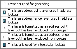
This column of the Layer Settings window defines how Think GIS does lookups.
The meaning of the symbols in this column are:
Click on the interactive image below for more information.
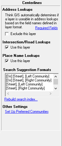
Exclude this layer from address lookups Check this box to prevent Think GIS from using this layer for address lookups. Think GIS automatically determines which layers are formatted for use as an address range or address point layer. So the user only has the option of excluding the layer if Think GIS displays this checkbox. This option, introduced in Think GIS ver4.22 replaces the "AddressLayerFilter" setting previously required in the Map Settings window. For more information see Address Finding.
Use this layer for intersection and road lookups Check this box for Think GIS to scan this layer for features matching the requested street names of an intersection or street name lookup. Any layer containing polylines can be used for intersection lookups.
Use this layer for place name lookups Check this box if this layer contains locations that are commonly searched for. Marking a layer as a placename gives that layer priority in location searches. These layers are searched by attempting to match the text in the first field of these layers. See Search Box topic for more about search rules.
|
Copyright © 2026 WTH Technology |