|
Alias List |
The Alias List is a place where an address administrator can define a set of search and replace rules that get automatically applied each time a user looks up an address. For example if a user requests "1000 S Dixie Bee Hwy" the alias list might automatically change that request to "1000 US HWY 41" to make it match what's on the map.
WARNING: Setting up a custom alias list automatically disables Think GIS's internal aliasing. If an alias list already exists, try removing it to see if results improve.
What is it used for:
•Allow the lookup of streets known by various names.
•Correct for commonly misspelled street names
•Force a standard convention of abbreviations
•Remove unwanted punctuation.
•Allow for alternate spellings or abbreviations of community names.
•Allow the use of community names even though the map only stores zip codes.
•Correct for misplaced or missing directional characters.
•Any of the above rules can even be limited to a certain town or a certain range of addresses if the same rules are not true in other parts of the map.
How to Edit the Alias List:
Aliases are stored in the advanced layer settings of the address layer. If more than one address layer exists, then users can store a different set of aliases for each layer. To start an alias list or edit an existing one do the following:
•Click the ![]() button on the main menu or select Layer Settings from the Setup menu.
button on the main menu or select Layer Settings from the Setup menu.
•Right click on the appropriate address layer and select Advanced Layer Settings.
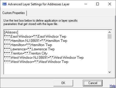
•A window will appear like the one below
•If there is not already a section titled [Aliases] then add one anywhere in the window.
•Add or modify any line below the Alias section using the alias formatting rules described below.
Format:
Each line of the Alias List defines a search and replace rule. Basically, any address request matching the content before the equals sign ( = ) gets replaced with the content after the equals sign. Each line can use either the simple format or advanced format. Each is described below:
Simple Format: Franklin Pkwy=ST RD 64
This format example makes it so when a user types in a street name of Franklin Pkwy, Think GIS will automatically change it to ST RD 64. This convention can also be used to replace portions of a street name. For example if the alias line read " road= rd" then any street names that spell out road would be abbreviated to rd. Note the spaces used on each side of the equals sign. Without the space included, this rule would incorrectly change Broad St to Brd St.
Advanced Format: 1100-1199,N,9th St,Clinton=N,Main St,Fairview
Using this format, users can more specifically say that any request for an address in the 1100 block of N 9th St in Clinton should actually be called N Main St in the town of Fairview. This format uses the syntax:
Low-High,Dir,Street,Zone=Dir2,Street2,Zone2
where:
•Low-High specifies a house number range. This rule would be applied to any address request that involves a house number within this range. Use an asterisk (*) to indicate that it applies to any house number.
•Dir specifies the pre-directional character that this rule is limited to. Use an asterisk (*) to indicate that it applies to any direction.
•Street is a complete street name that must exactly match the requested street name before this rule is applied. Use an asterisk (*) to indicate that it applies to any street (such as when doing a community name correction)
•Zone specifies a zip code or community name that this rule is limited to. Use an asterisk (*) to indicate that it applies to any zone.
and
•Dir2 specifies the pre-directional character that should be applied to the requested address. Use an asterisk (*) to indicate that the direction should remain unchanged.
•Street2 specifies the complete street name that should be applied to the requested address. Use an asterisk (*) to indicate that the street should remain unchanged.
•Zone2 specifies the zip or community name that should be applied to the requested address. Use an asterisk (*) to indicate that the zone should remain unchanged.
•A comma must be included between each field even if a field is blank.
Compounding Rules:
All rules listed in the Alias List are tested against the requested address in the order they are listed. This means that it is possible (and often by design) that more than one rule might get applied.
|
Copyright © 2026 WTH Technology |