.png)
|
Receive input from Other AVL Servers |
This feature, found on the Input Tab, can allow users to see units from other WTH AVL Servers from different departments. This is an ideal feature for departments that do mutual aid for one another, or if a county has more than one department with their own AVL Server.
Click on the interactive image below for more information.
Notes:
Some advanced situations require the use of multiple AVL Servers tied together. A couple of common scenarios that might demand this are:
•Two neighboring agencies each have their own AVL Server but they want to be able to see each others cars on their maps.
•One multi-department agency tracks thousands of vehicles and has hundreds of map users wanting to view the fleet. Multiple AVL Servers are needed to handle the traffic.
How To Tie Two Servers Together
Two AVL Services are "tied" together by configuring server 1 to get input from server 2. The result is that all vehicle locations tracked by server 2 now get relayed to server 1 so that anyone using Think GIS to monitor server 1 now sees both server 1 and server 2 cars. All setup work is done on the Input tab of server 1. Click Add below the server input list to display the Server Input form.
Two Way Communication
The above scenario only provides one way communication between two servers. In many applications it is advisable to configure server 2 to get input from server 1.
Monitoring Multiple Servers In Think GIS (Alternate Solution)
Not all "information sharing" scenarios between agencies require interfacing the AVL Servers. One alternate solution is to leave all AVL Services running independently and configure each Think GIS workstation to monitor all of the AVL Services. A WTH service representative can help determine which scenario is best. See example 1 below.
Managing Colors, Icons, and Groups For Relayed Units
By default, relayed units will appear in the List Of Units and on the map with the same icon and/or color configured on the AVL Service that they came from. To prevent these units from being confused with the agency's, force all relayed units to a uniform color. Likewise, relayed units can be automatically assigned to a certain vehicle group if needed to control which users can monitor these units.
Limitations
•Relayed unit locations do not get recorded to the history. The AVL Service only records history for units that it is directly monitoring. To query units outside of the agency's AVL server is to connect the AVL Administrator directly to the AVL Service that the units are being relayed from.
•Currently, unit notes are not relayed. This means when clicking on a relayed vehicle on the map display, it may not show speed and other details that are available for other vehicles.
•Relayed information cannot be nested. That means, for example, that if server 2 is setup to get input from server 3, and server 1 is setup to get input from server 2, then server 1 will not automatically see the vehicles tracked by server 3. To accomplish this, configure server 1 to get input from both server 2 and server 3.
•Relayed units show up in the List Of Units with a two digit prefix indicating the server that they came from. "00:" indicates that this unit was relayed from the first server in the Server Input list. "01:" indicates the second server, etc.
Using Multiple AVL Servers For Improved Performance
The performance limitations of a single AVL Server is dependent on the number of vehicles being tracked, the rate that they are reporting, and the number of clients (ie. Think GIS users) that are viewing this information. A rule of thumb is that a single AVL Server will support 500 vehicles each reporting every 5 seconds with 50 clients connected. For larger installations it is necessary to use multiple AVL Servers.
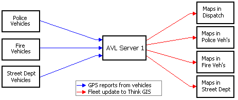
Example 1 - Simple
Before we look at a complex example lets look at a simpler one. In the illustration below, a small city uses a single AVL Server to track vehicles from several departments. Even though all vehicles are sending their GPS reports to the same server, it is possible to limit which map users see which vehicles by using vehicle groups. See Using Vehicle Groups for help on setting up the user logins, permissions, and groups required to do this. This way the street department users can only see street department vehicles, the fire department users can only see fire vehicles, and the dispatch users can be setup to see both fire and police vehicles. This same type of setup limits which vehicles can be queried for vehicle history.
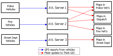
Example 2 - Server sharing controlled by Think GIS
This second example shows what a larger city might look like where multiple AVL Servers are needed to handle the larger number of vehicles and map users. In some scenario's this would simply be three independent AVL Servers. But in this example lets say that the police department wants to be able to monitor both the police and fire vehicles even though the fire vehicles are managed by a separate AVL Server. One way to do this is to configure the Think GIS mapping software on select police clients to get fleet updates from both AVL Servers. (See "Multiple AVL Servers" in Think GIS) This solution does require that each Think GIS computer have TCP/IP access to the AVL Servers that it wants to monitor. One of the pro's of this type of control is that it doesn't require any type of vehicle groups or user login setup on the AVL server. And even though access is setup on the individual clients, the system administrator can still control access to the server. See "System Security" in AVL Service.
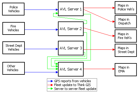
Example 3 - Server sharing controlled by Server
This third example illustrates setting up the AVL Servers to get fleet state from each other. One advantage of this over the configuration in example 2 is that it moves the setup from the client to the server. A second advantage that this has over example 2 is that it greatly reduces the number of clients that are reading fleet state from server 1. In this scenario, the police department's AVL Server is setup to get input from the fire department's AVL Server. Now any Think GIS computers monitoring the police department's AVL Server will see both police and fire vehicles. If necessary, vehicle groups can be configured to control which Think GIS users are allowed to see the fire vehicles. This server to server link does increase the incoming traffic to server 1. If necessary, this link can be setup to get its updates at a slower rate such as once per minute. The result would be that the police department map users would only see the fire department vehicles update once per minute while the police cars would update at their regular rate.
This example also adds a fourth agency (County or State EMA) to illustrate how an additional AVL Server might be used to collect updates from a very large number of vehicles and then distribute them to users who want to monitor everyone.
|
Copyright © 2026 |