|
List Tab |
The bearing and distance window is used to move the cross hairs a precise bearing and distance from its current position. Users can use it to draw a single line segment or to draw an entire property description. To display this window press the D key while in line drawing or area drawing mode.
Click on the interactive image below for more information.
How to draw a simple area using the List Tab :
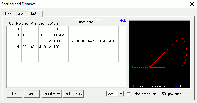
The above illustration shows how to enter the following example deed.
"Starting at SW corner of ..., proceed north 90 degrees east a distance of 500 feet to the point of beginning then proceed north 45 degrees 11 minutes and 30 seconds east a distance of 1414.2 feet then proceed along an arc concaved to the right having a radius of 750 feet and defined by a chord bearing due south a distance of 1000 feet, then proceed north 89 degrees 49 minutes 41.8 seconds west a distance of 1001 feet to the point of beginning."
1) After starting the draw area tool (or parcel split wizard), use the cross hairs to click on the survey's point of origin as defined by the first part of the description. For example, "the SW corner of the NE quarter of section 36 of Center Twp."
2) After picking the point of origin press the D key to display the Bearing and Distance window.
3) Using the List tab type in the bearing and distance calls as in the above example. If using the numeric keypad, use the Enter key to tab from field to field.
4) Place an X in the first column on the row that starts the Point of Beginning.
5) To specify a curve place the cursor on the next blank line and then click the Curve Data button.
6) Click the OK button when finished. If the description does not close, a prompt to automatically close it will appear.
Column Descriptions
POB: Place an X in this column on the row that starts the survey's point of beginning.
NS: (N)orth, (S)outh, or (D)eflection
Deg: Degrees
Min: Minutes
Sec: Seconds
EW: (E)ast, (W)est, (L)eft, or (R)ight. L and R are only used when NS=D.
Dist: Enter the distance here. Units are specified in the pull down list at the bottom of the window. To specify distances in rods, chains, and/or links first select RCL in units pick list and then enter distance values using R,C,L, or F prefix. For example, "C1 R2 L5" equates to 1 chain plus 2 rods plus 5 links.
Radius: When specifying an arc enter the arc radius here.
LR: When specifying an arc type indicate here if it is concaved to the (L)eft or (R)ight.
How to specify deflection:
Some calls may be specified in the form "... then deflecting left 10 degrees a distance of 100 feet ...". This syntax indicates that the angle is relative to the previous bearing. In this rare case type a 'D' in the NS column, enter the angle as normal, and type an L or R (left or right) in the EW column.
Other notes:
•It is important that the cross hairs first be positioned at the survey's point of origin on the map before typing the description.
•To edit curve data first click on the line containing the curve and then click the curve data button.
•Keep in mind that due-north is not always straight up on the screen. This varies based on what projection the map uses and where entities are drawn within that coordinate system.
•See also the Parcel Split Wizard.
•This form also provides a means of automatically labeling the property dimensions.
|
Copyright © 2026 WTH Technology |