|
AWS Feature Link (Web) |
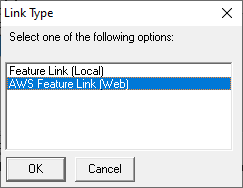
Clicking the Add on the Feature Links window will pop up the Link Type window below. Choose the applicable link type and click OK.
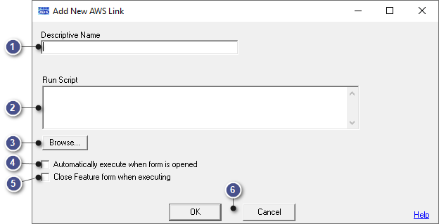
The following describes the AWS Feature Link (Web), for more information about local links click here. The action of the link is defined by one or more Think GIS commands listed in the Run Script window below.
|
Descriptive Name |
|
|
Type here the name of the link as is should appear on the Feature Form. |
|
Run Script |
|
|
This area will allow users to input one or more Think GIS commands that are to be executed when the link is clicked. See Examples. |
|
Browse... |
|
|
The most common type of Feature Link is one to open a file, such as a floor plan image or pre-plan. This option allows the user to browse to the desired file and automatically populates the Run Script section with the correct values. When changing an existing link, browse will replace the existing link with the updated one.
Supported file types: AVI (*.avi), BMP (*.bmp), CSV (*.csv), GIF (*.gif), JPEG (*.jpg *.jpeg *.jfif), JSON (*.json), Microsoft Office (*.doc *.docx *.ppt *.pptx *.xls *.xlsx), MP4 (*.mp4), MPEG (*.mpg *.mpeg), Open Document (*.odp *.ods *.odt), PDF (*.pdf), PNG (*.png), Text (*.txt), TIF (*.tif *.tiff), XML (*.xml) |
|
Automatically execute when form is opened |
|
|
Check this box to indicate that the link should be automatically launched any time the user double clicks on this feature in the map display. |
|
Close Feature form when executing |
|
|
Check this box to indicate that the Feature Form should be automatically closed anytime this link is clicked. The effect of having both Auto-execute and Auto-close checked is that the link content gets displayed in place of the standard Feature Form anytime the user double clicks a Feature on the map display. |
•The file linked will be available to anyone using the map, providing they have a working internet connection
•Any license that needs to access these links must be running version 4.44 or newer.
•The Feature Link Window may be resized by mousing over the corner until expansion arrows appear, then left-click and drag the corner out or in to resize the window.
•The Descriptive Name box allows up to 31 characters.
•The Run Script box allows up to 191 characters.
•A warning message will pop up each time a link is created or converted.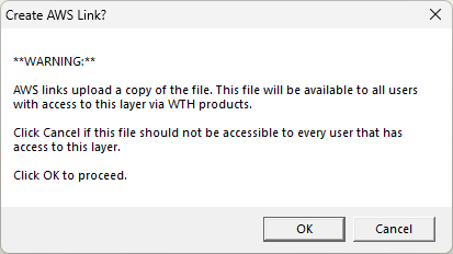
•AWS linked files are downloaded and stored in a Downloads folder relative to the TMDIR. Within that folder files are stored in sub folders with the corresponding Layer GUID. Files with the same name in the same folder will get overwritten when downloading.
•Think GIS will attempt to open the file using the default browser. If it is a file type not commonly supported by browsers, it will instead open in the computer’s default application for that file type. The standard Windows prompt to select an application will be displayed if neither is available.
|
Copyright © 2026 WTH Technology |