|
Linked Database Fields |
Use the Add Linked Database Fields button on the Layer Format window to add virtual fields to the Think GIS layer that display live data from any ODBC compliant external database such as an MSAccess file, Excel file or Database Server. Once the linked fields are setup, they will appear in the Index as columns just like normal fields and they will appear on the feature form whenever users double click something on the map.
To add linked database fields to a layer
1) From the Layer Format screen click the "Add Linked Database Fields" button.
2) Read and follow the database connection setup wizard screens. For help with any of these screens see Database Connection Wizard.
To Modify a linked database field
Note: Editing the properties of a linked field involves understanding some complex syntax like SQL and Driver connection string syntax so users might find it easier to simply remove the field and re-add it using the connection wizard.
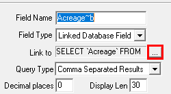
1) On the Layer Layer Format screen select a linked field from the field list
2) Click the ellipses button to the right of the "link to" box.
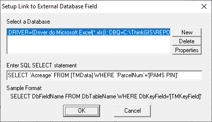
3) Edit the information in the window that appears (see example below)
Query Type:
The Query Type property applies whenever the linked database contains multiple records that match the link criteria. Most linked fields are designed to only find one matching record.
Comma Separated Results When multiple results are found, each is listed separated by commas.
Line Separated Results When multiple results are found, each is listed separated by carriage returns
First Result Only When multiple results are found, only the first one is displayed.
Notes:
•Linked fields can be used for labeling and classification.
•Linked fields cannot currently be edited or searched.
•The display length property is used by various parts of Think GIS to suggest the recommended display length of results expected in this field. Most importantly this is used as the dbf field length if this layer were to be exported to a shapefile.
•When the Decimal Places property of a Linked field is greater than zero the resulting value will be forced to a number. In this case any text will not be displayed.
•See also the Import/Export menu for ways to do a one time import of data from external databases.
•See Database Errors for a description of error messages such as "-DB Err 8-"
•Linked Database fields can not be used as Sort fields.
|
Copyright © 2026 WTH Technology |