|
Auto Labels |
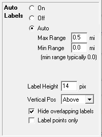
Auto labels are computer generated labels that appears next to their corresponding entities on the map display. This provides a quick and easy alternative to the manual process of placing custom labels throughout the layer.
To setup auto labeling for a layer
1) Open the layer settings window
2) Click in the Auto Label column of that row.
3) Select the desired auto label properties as described below.

On Auto labels are always displayed regardless of map scale.
Off No auto labels are displayed
Auto Auto labels automatically turn on when zoomed to a desired scale. This scale is controlled by specifying a minimum and maximum display range. Display Range is the approximate height of the viewable portion of the map measure in miles. The closer the map is zoomed in, the smaller this value gets.
Max Range: Do not display auto labels if zoomed out further than this.
Min Range: (Most commonly set to 0) Do not display auto labels if zoomed in closer than this.
Max Shield Range: This is a special option only present when the layer is configured with a "Shield Text" field for labeling highway shields. This allows users to specify a display range for the shields different from the display range for non-shielded labels. This value must be greater than or equal to the Max Range value. See Text Properties for more about shield labeling.
Label Height Height of all auto labels measured in pixels. This has no affect on the height of custom labels.
Vertical Pos How the label should be positioned relative to the line or symbol that is being auto labeled.
Hide overlapping labels When this box is checked, Think GIS reduces the number of labels in congested areas so that labels do not overlap. This makes the map more readable and allows auto labeling to be turned on a larger display ranges. But this may require the user to zoom in closer to see some labels.
Notes:
•Only one auto label is generated for each feature in the display.
•The "Hide overlapping labels" option described above was introduced in Think GIS version 4.22. This replaces the "HideOverlappingLabels" setting previously required in the tm4.ini file.
•To control which data fields are included in the label see Layer Format.
•Both auto labels and custom labels are displayed using the text properties listed in the layer settings window
•Auto labels are not generated for features that have custom labels visible in the current view
•See also Custom Labels.
|
Copyright © 2025 WTH Technology |