|
Layer Visibility |
To turn a layer on or off:
1) Open the Layer Settings window.
2) Place a check in the appropriate visibility column for that row.
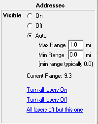
3) See details area for additional visibility options (sample below).
On Layer is visible.
Off Layer is not visible
Auto Layer automatically becomes visible when zoomed to a desired scale. Users control this scale by specifying a minimum and maximum display range. Display Range is the approximate height of the viewable portion of the map measure in miles. The closer users zoom in, the smaller this value gets.
Max Range: Do not show layer if zoomed out further than this.
Min Range: (Most commonly set to 0) Do not show layer if zoomed in closer than this.
Turn all layers On A quick way to turn all layers on
Turn all layers Off A quick way to turn all layers off
All layers Off but this one A quick way to isolate this layer.
Notes:
•To turn several layers on or off at once, click in the appropriate column and hold down the left mouse button while moving the mouse up or down. Each layer passed over will be assigned this visibility.
•The On/Off buttons next to a layer category can be used to turn all the layers in this category on or off all at once.
•Another method of controlling layer visibility is through the use of the number keys along the top of the keyboard (not numeric key pad). See Map Navigation Shortcuts for more information.
•Even though a layer's visibility is turned off it can still be used in index lookups, and queries.
•Only visible layers are included when manually selecting entities on the screen.
•Like most other layer settings, visibility is stored in the map file (.tgm).
|
Copyright © 2026 WTH Technology |