|
Mark Waypoint |
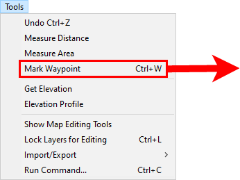
This menu item, located on the Tools Menu, provides a simple way to quickly mark a reference point on the map.
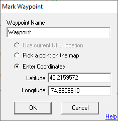
This tool is motivated by the need for officers to quickly mark map locations, such as evidence, while in pursuit. But it functions generically enough to be used for a wide variety of applications on both Editor and Viewer versions of Think GIS. Waypoints are an extension of the GPS Track Log feature of Think GIS and therefore users must have GPS enabled before waypoints can be recorded. The waypoint gets stored in the same _Gps_Track_Log_ layer. Like any other menu item, users can create a custom button on the toolbar for this action. There is also a "MarkWaypoint" command that can be used to alter how the tool performs. The mark waypoint screen is designed so that an officer in pursuit can simply press Enter when the window appears and his current GPS location gets recorded. However, there is also the option to give the point a descriptive name and/or select a more specific point on the map different from the GPS position. The GPS coordinates for the waypoint are captured when the mark waypoint screen is first opened, so there is no hurry to complete the form and click ok. The "Use current GPS location" option is disabled if no GPS location has been received within the last 30 seconds. Waypoints are kept forever in the Track Log even if the track log gets regularly purged of old track data. Users can manually delete waypoints or edit waypoint names from the index screen.
When entering the coordinates for a waypoint, use any of the following formats:
Format Example Description
DDD.D 40.12345 Degrees
DDD MM.M -85 12.34 Degrees + Minutes (separated by space)
DDD MM SS.S 39 12 34 Degrees + Minutes + Seconds (separated by spaces)
|
Copyright © 2026 WTH Technology |