|
Configure Report Parameters |
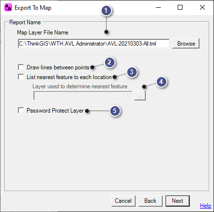
This configuration window is used to set the parameters for the Export to Map report, and it is accessible on the History Tab > Export to Map.
|
Map Layer File Name |
|
|
Manually enter a new name/location, if desired, or use the Browse button to navigate to a new file location. |
|
Draw lines between points |
|
|
The layer will contain a point for each vehicle report. Checking this box will insert a line with arrows denoting direction of travel between each. |
|
List nearest feature... |
|
|
If checked, the exported layer will have a field containing the nearest feature from the selected layer (Below). |
|
Layer used to determine... |
|
|
This area will only be active if the "List nearest feature..." box is checked. Click the box to the right of the display window to open a list of layers in the map and select the layer to be used in this query. The Long Label of the selected layer will be used to populate this field.
|
|
Password Protect Layer |
|
|
Checking this box will ensure that the layer can only be viewed by users with the devised password. When this box is checked, a blank field will appear to enter in password.
|
|
Copyright © 2025 |