|
Configure Location Parameters |
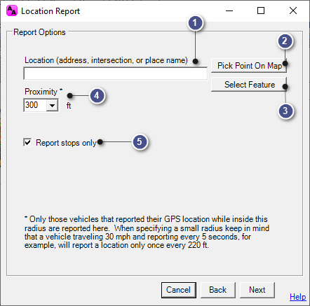
This configuration window is used to set the parameters for the Location report, and is accessible on the History Tab > Location Report.
|
Location (address, intersection, or place name) |
|
|
This window will allow the user to manually enter a location by either address, intersection, or place name. (The latter will require that a layer(s) contents have been configured to be used as a place name in the Layer Settings in Think GIS.) If the location is selected using another method, that location will be displayed here. |
|
Pick Point on Map |
|
|
This button will move the user to Think GIS, allowing specific location of the map to be selected by placing the mouse cursor over the desired point, and then left-clicking on the mouse.
|
|
Select Feature |
|
|
This button opens a new window reminiscent of the Index in Think GIS. Select the layer, and then the feature to be used as the location here.
|
|
Proximity |
|
|
Select the number of feet from the location to be queried. This number represents the distance from the point as a radius. |
|
Report Stops Only |
|
|
Checking this box will ensure that the report only shows vehicles that have remained stationary for a specified period of time. |
|
Copyright © 2025 |