|
Snaps |
During any process where users are prompted to pick a point on the map it is sometimes desirable to pick a point along an existing line. Drawing aids called "snaps" are used to assure that the point picked lines up exactly with any nearby entities whenever that is the intention.
How it works:
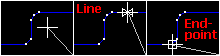
Move the cross hairs near another entity a small symbol appears. This symbol indicates that Think GIS is assuming users intend to pick a point exactly lined up with this entity. The type of symbol indicates the type of alignment:
Bypassing snaps:
Hold down the Shift key at any time to temporarily turn snaps off allowing free-hand to pick a point near another entity.
Snap distance:
The SnapDistance parameter can be set in Workstation Settings controls how close to be to another entity before the snap boxes appear. For example, "SnapDistance=4" specifies that snaps appear when users are within 4 screen pixels of an entity.
Displaying snap points:
During any drawing process, pressing the 'S' key will highlight all existing line segment end points on the screen. These points produce the square snap box whenever the cross hairs near them. To display these points more permanently press Ctrl-S. This highlights the points and leaves them highlighted during map use. To turn them back off press S again.
|
Copyright © 2026 WTH Technology |