|
Draw a New Parcel (split) |
This option, located on Tools Menu > Show Map Editing Tools > Production Tools > Parcel Split Wizard, is used to split an existing parcel with a new parcel. After completing the first two steps on the Parcel Split Wizard page and selecting this option, continue as detailed below:
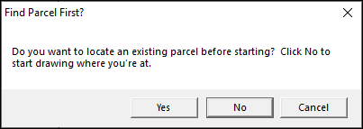
1) Clicking Yes will bring up the Index, allowing the user to search for and locate the desired parcel location. It is advised that the user first zoom to the location of the desired parcel before starting this process. If the latter is done, then click No.
2) Place the cursor over the Point of Beginning (POB), left-click and leave the cursor on the POB, and then press D on the keyboard.
.png)
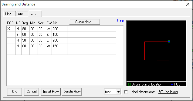
3) The Bearing and Distance tool will pop up. Fill in the calls from the deed and then click OK:
•POB: The Point of Beginning refers to the beginning of the new parcel. If the deed has a series of calls that lead to the POB, place an X in this column on the row where the new parcel actually begins. All linework drawn before the X will be removed from the final drawing.
•NS: Input the first direction of the call with either North (N) or South (S).
•Deg: Input the degrees from the call.
•Min: Input the minutes from the call.
•Sec: Input the seconds from the call.
•EW: Input the last direction of the call with either East (E) or West (W).
•Dist: Input the distance from the call.
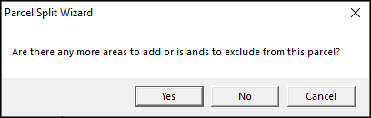
4) If the parcel has any cutouts or islands, click Yes and repeat step 3 to draw those in; otherwise, click No.
5) The map will prompt to place a manual label. Left click inside the parcel lines OR right click to skip this step.
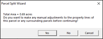
6) If any manual changes are needed to edgematch, or otherwise adjust the final parcel, click Yes and use the Move Tool to make the adjustments; otherwise, click No.
7) The new parcel will now be on the map.
.png)
Notes:
•Users can edit UseParcelSplitManualLabels setting in the tm4.ini. This setting defaults to =1; setting it to =0 will skip the Manual Label step(5 above) in the Parcel Split Wizard's Draw a New Parcel (split).
|
Copyright © 2026 WTH Technology |