|
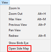
Open Side Map |
Select this menu item from the View menu to display a second map window centered on the current view. This side map will then stay zoomed at the same view as users continue to use the main map display for other things. Any AVL and Event activity will also show in the side map. Users can open up to 16 side maps and even drag them to separate monitors. Side maps can be resized but are limited to 400X400 pixels in size. Side maps will automatically close when the main Think GIS window closes.
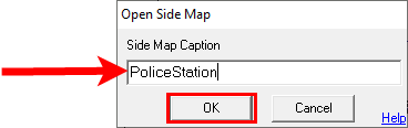
The side map will default to the name "Side Map 1," though the number will go up as more side maps are opened. It may be changed in this first pop up, then click OK.
To Automate the opening of Side Map's use the OpenSideMap command. This command can be used to automatically open one or more side map's when Think GIS starts up or to create buttons or function keys that can automatically open a certain side map. See Command Line Interface for techniques on how to do this.
Use a side map as a large birdseye view of the entire jurisdiction. Or use them to keep an eye on certain points of interest such as the comings and goings at police headquarters. Side Maps can also be used to track individual AVL units.
|
Copyright © 2026 WTH Technology |

.png)