|
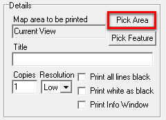
Map Area |
Click the Pick Area button to select the map area to be printed.
Click on the Think GIS display indicating the location and scale of the printout when prompted. Once the correct area and scale are set, left clicking will return the user to the print window with the newly selected area displayed.
Mouse/Keyboard Aids
•Use the mouse scroll wheel or page up/page down keys to change the scale before clicking.
•Use the 'S' key to enter a specific print scale. Use format 1" = N ft or 1" = N mi
•Hold down the shift key to scroll through the print scales in smaller increments.
This button can only be used to pick the area of the main map graphic on the print layout. To change the print area for a map insert first click on the map insert in the preview area and then click on the 'Print Area' property in the properties window in the lower left corner of the screen.
See also Pick Feature
|
Copyright © 2026 WTH Technology |
.png)