|
Server Side History Report Resources |
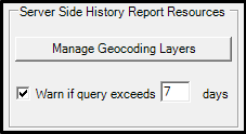
This section is part of the Input Tab and is used to give end users more robust History reports by incorporating the GIS data of the AVL coverage area.
Click on the interactive image below for more information.
Notes:
•The ability to configure geocoding layers to be updated from sync began in version 1.22.11.914. If layers were set up in previous versions, they will continue to use the static server side layers until the configuration is updated with files from the customer specific sync groups.
•This section is typically set up at the time of server deployment, by or with WTH assistance, and does not need to be modified unless there are significant changes made to the GIS layers that are used for geocoding. Significant changes include field name changes or new address or centerline/road/address range layers. Data updates to existing layers will be automatically utilized based on data available from Sync. If this section is not set up, please contact WTH for assistance.
•The layers selected should be layers that are actively being maintained.
|
Copyright © 2026 |