|
Auto Pan |
Check this box for Think GIS to automatically follow the unit running it as it drives around the map. Think GIS does this by re-centering the view on the users location whenever the unit drives out of the current view.
If the user manually zooms to some other location on the map while this option is checked, Think GIS will not automatically re-center the view (this would be annoying). The Auto Pan feature only works when the unit is driven out of the current view.
This feature also comes into play when an address is located. If an address is located with this option checked, Think GIS will zoom to the tightest view that includes both the address and the unit's location. Then, assuming that the unit is driving to this location, Think GIS will continue to automatically zoom in closer every 15 seconds as it is approached.
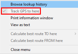
This ability to track to a location on the map actually works with more than just address lookups. It can be enabled or disabled for any currently highlighted feature by clicking the ![]() button at the top of the Information Window then "Track GPS to here."
button at the top of the Information Window then "Track GPS to here."
|
Copyright © 2026 WTH Technology |