|
Import From Text File |
Use this tool, located on the Tools Menu > Import/Export Menu, to import features from a comma delimited text file. In addition to populating text fields this tool can automatically place symbols on the map based on addresses or lat/lon coordinates stored in the same file.
To Import from a text file:
1) From the main menu select Tools - Import/Export - Import From Text File.
2) Locate the file to be imported (typically a TXT or CSV extension)
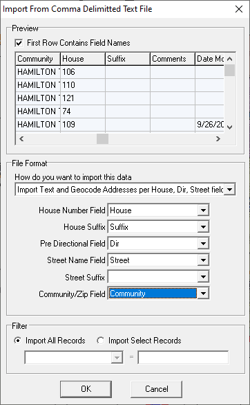
3) Based on the preview window that appears (see example below) check or uncheck the "First row contains field names" check box.
4) Select the import method from the pull down list that best defines the contents of the file being imported. See description of each of these options below.
5) Based on the selection above, users may be prompted to indicate which columns in the text file contain certain fields. Select a source column for each of these fields and then click OK.
Import methods:
Import Text only: Think GIS will create a new layer with the same fields provided in the text file and import each row as a feature on this layer. No entities will be drawn on the map.
Import Text and Geocode Addresses per Address Field: Think GIS will import the text just as with the above method but it will also attempt to locate the given address and place a symbol entity on the map at that location associated with each feature. When this method is selected, the user will be prompted to specify which column of the text file contains the address and which column contains an optional Zone (ie. community name, zip code, city name)
Import Text and Geocode Addresses per House, Dir, Street fields: Works just like above method but used when given addresses are parsed out into multiple fields. When this method is selected, users will be prompted to specify which columns of the text file contain the house, direction, street name, and zone fields.
Import Text and Plot Symbols per Latitude, Longitude fields: Think GIS will import the text just as with the Import Text method but it will also place a symbol entity on the map at the location indicated by a given latitude and longitude value.
Import Text and Plot Symbols per Northing, Easting fields: Works as the Lat/Long option does. When selected, simply identify the Northing and Easting in the File Format section.
Notes:
•This tool replaces the now obsolete "Import Addresses" and "Import Points" menu items.
|
Copyright © 2026 WTH Technology |