|
Graphic Properties |
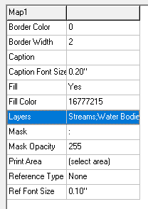
The Graphic Properties window in the lower left corner of the page displays several properties that can be set for the currently selected graphic in the preview window. Below is a list of all properties with a brief description for each. Note that many of the properties only apply to certain types of graphics. The below image is an example of properties for the map image in the print window.
Associated Map: For scale bar graphics this property determines which map the scale bar is associated with. If placing the scale bar on top of a map graphic this property will be automatically set to match that map.
Bold: Draw text as bold
Border Color: Color of rectangle border around graphic.
Border Width: line width in pixels for the graphic border. Set to zero to turn border off.
Caption: Text displayed at top of map insert window.
Caption Font Size: Size of Caption text
File Name: location of image file used by picture graphic. Can be BMP, PNG, JPG, or GIF.
Fill: Set to No if background color of graphic should be transparent.
Fill Color: Background color of graphic. Used only when Fill is set to Yes.
Font Color: Color of font
Font Name: Type of font
Font Size: Height of font in inches.
Fore Color: Color used by certain graphics like scale and north arrow
Horz Align: Horizontal alignment of text within box
Italic: Set to yes to draw text as Italics
Layers: Forced list of layers used by Map or Legend graphic. Set to 'Auto Select' to let THINK GIS automatically determine which layers to include.
Line Width: Line width in pixels used by certain graphics like scale and north arrow
Margin: Amount of space to be reserved between border and graphic content.
Mask: Name of layer and feature defining boundary to be used as mask on map graphics. A mask is used to hide all portions of the map outside of a certain area.
Print Area: Click the button next to this property to select the portion of the map to display in this window.
Reference Type: This property determines how a map insert is visually linked to the main map graphic.
Ref Font Size: This is the font size used to display a message on the main map referring to a map insert. This is only used for certain Reference Types. This property is set for the map insert.
Style: Determines the style for graphic types like scale bar and north arrow.
Text: Type here the text to be displayed in text type graphics. Users can also click on a text graphic and type directly onto the preview window.
Transparent: Used with Picture graphics. When set to true, all pixels matching the color of the lower left pixel will be drawn transparently allowing the image to appear to have a shape other than a rectangle.
Underline: Set to yes to draw the text as underlined.
|
Copyright © 2026 WTH Technology |